It's lunchtime!
Stormtrack.org is a website that serves severe weather enthusiasts. It has a particular focus on forecasting tornadic supercells and chasing them. During the off-season, some of the experienced members post "Chase Cases" where they pull up meteorological data from previous severe weather outbreaks without providing dates, and then gradually posting the information to give everyone a chance to forecast and do a virtual chase. I'm too inexperienced to post anything useful in the discussion, so I thought I'd post my own thoughts and results here as the chase goes on, to see how I do.
Earlier this week, they posted Chase Case #1 that involved a low pressure system moving out of the rockies into the Dakotas. In an effort to be realistic, I try to assume that I'll either start my chase from Flagstaff or from Elk City, Oklahoma. Being even more realistic, I figured there was no way I would chase as far north as the Dakotas unless I was really sure I knew what was going on. I saw a dryline positioned in western Kansas and thought I'd go for that as moisture moved up from the south. But I didn't think about how strong the CAP was in the area, and all I got to see were some small popcorn cumulus in the late afternoon. South Dakota went nuts with severe weather and tornadoes on that day, which turned out to be June 7, 2005.
And now on to the current chase case.
0Z Update:
A cold front is drooping down into the northern plains while a pronounced dryline is positioned southward from the Texas/Oklahoma panhandles. Rich moisture pooled in south Texas with surface winds pushing west-northwest. Directional shear looks really good across Texas and Oklahoma. Soundings don't look good to me in my limited experience, anywhere except the Del Rio sounding on the Texas/Mexico border where afternoon thunderstorms are blooming in all the moisture.
I'm not at all familiar with how a dryline and incoming moisture behave when the cold front is not pushing in from the west. I don't know if the drooping cold front will help with forcing in Kansas and Oklahoma. So I'm going to start my virtual chase from Elk City and will drive southwest to Lubbock, Texas, to get closer to the incoming moisture, high dewpoints, and to get in the vicinity of the dryline. I'm getting up at 2 AM to make the 4 hour drive and with stops and naps, would probably arrive at 7 am. I'll find a starbucks and check the 12Z data on my iPod. Then I can decide whether or not to head further south.
I just noticed a couple comments at the site about a possible "Caprock" event. I believe this refers to a geographic feature in west Texas that provides some orographic forcing. So I think if you can get additional help from the dryline, you can get a focal point for storms. We shall see.
06Z Update
A 6Z weather service text update is posted.
If I were to check this before leaving at 2AM, it would probably influence my decision to leave Elk City at all. The weather service text in this update notes potential for severe thunderstorms east of a line from Amarillo to Hill City, KS and on into Nebraska. So, this all seems to set up much further north than I anticipated. The WS update shows that the moisture in the Rio Grande valley will be drawn northward by a 30-50KT low level jet. That's something I need to pay attention to in the future--is there a low level jet, and if so, is it positioned to maneuver available moisture.
Another issue is that the severe forecast did not extend much further down toward the Rio Grande. One participant in the Chase thread commented that mid level air temps were rather warm in southwestern Texas, and this would stabilize the air. One thing I need to understand is how to determine conducive temperatures at different levels in the atmosphere. Right now, I'm completely lost in this area.
The report does note current convection over Northwest/North-central Texas that could lead to an outflow boundary in Western Oklahoma/East-Texas Panhandle that would greatly enhance severe potential.
Anyway, I committed to Lubbock already, and rather than change the destination, I'll punish myself by wasting virtual fuel when I'll likely need to backtrack. I should still well set to easily reposition for action on the southern side of things in the panhandle. I love looking for outflow boundaries on morning satellite. It'll be interesting to see what shows up at 12Z.
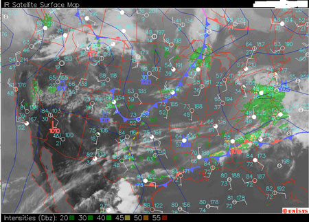
Looking at the 12Z Update satellite imagery, I think I see two outflow boundaries. One crossing the Red River in SW Oklahoma and another in the eastern Texas panhandle. The Temp/Dew Point data in the surface plot seems to show very moist air all over the plains. The dry line drapes from SW Kansas, through the western panhandles, and cuts to the southwest through eastern New Mexico. The 850 Mb chart shows winds pushing the moisture northward across the panhandles. Directional shear looks awesome all the way up, and the 300 Mb chart shows a 70-90Kt jet over the panhandles, Oklahoma and Kansas. CAPE over Amarillo is at a gorgeous 2805.
I'd like to be near the outflow I think I see in the eastern TX panhandle and further north to get closer to better upper level winds. So I'll make the 2.5 hour drive up to Memphis, TX, arriving there about 10:30 AM where I can check the 15Z update.
OK. I've been schooling myself on chart analysis at this excellent site: Weather Prediction Education. There's a whole lotta work to be done, but I'll try and dig a little deeper each time.
If things go well on this virtual chase, it won't be because I got to the right spot for all the right reasons. I didn't look for Vort Max indicators at 500 mb, check for large tdd at 500/700 mb, look for short waves at 700 mb, look for low level convergence/confluence, or look for upper level divergence/diffluence over unstable air, look for jet streaks at 300 mb...and a million other things. Anyway, at this point, it will be about watching satellite, radar, surface plots, and text updates. So the better map mojo will have to wait for the next chase.
The 15Z Update shows a storm complex over south-central Oklahoma with hail potential, but not worthy of a warning. This may help push more outflow for things to work on later in the day. The dryline is still hanging way back at the New Mexico border and SE Colorado. Convergence isn't strong along the dryline, but it's only 9 AM, and the moist surface air hasn't had a chance to mix out or the winds to pick up. So I'm going to stay where I'm at and grab some virtual nap time in Memphis, TX.
It's noon, and skies aren't clearing over the eastern panhandle. Will that kill surface heating enough to deaden the area? Then there's the dryline. It's not advancing. I wasn't sure what it was going to do without a cold front pressing it from the west. Now it looks like there is a surface low spinning over western Colorado, and I don't know if it will move eastward in time to push the dryline along. In fact, I don't know if there will be enough convergence along the dryline to make it a good source of strong convection. Winds behind are from the south-southwest, and winds ahead are from the south-southeast.
I think that would bother me enough to start heading northwest where I can get at least closer to clearing skies and the upper stretches of the dryline. I'm driving up to Claude, TX...the name sends a shiver down my spine...
Whew! Didn't have to stop long in Claude! The 19Z shows that
dryline just sitting there, but
cumulus are starting to pop along it's boundary. So onward through Amarillo and up to Dumas, Texas. I should get there by 3 PM and anticipate I'll want to shoot on west then NW toward Dalhart, Texas where I think I see a dryline bulge. That will depend on development noticed along them way. I'll have satellite and radar bookmarks ready to go on the iPod so I can check quickly at the nearest Starbucks or hotel parking lot and adjust path in Amarillo, Dumas or elswhere along the way. Now, watch something unanticipated kick off convection where I was at...
Stopping in Amarillo, I check the 20Z update to find that convection is strengthening along the dryline, and it appears to be pushing eastward a bit now. I'll push on toward Dumas and see how things look from there. I should arrive there about about 3:20 PM (2120).
Something worked here! I approach Dumas as a storm with a great radar signature is blooming over the town. (I doubt I would stop to check radar and would just hop on this storm to see what it's doing.) Storm motion appears to be a bit north of east at 30 mph. I'll try following this cell eastward on Rt. 152 through Stinnett (reaching Stinnett at 4:00 PM (2200)) and then up Rt 207 toward Spearman if it seems productive and conditions allow.
At 22Z along Rt. 152, the storm is growing, and it looks like I'm able to keep pace with it as it tears things up 5 miles to the north. The radar signature still looks great.
At 2230Z, I've broken off Rt 207 and taken Rt 136 straight north toward Morse, to get closer to this monster as it stradles the Hutchinson/Hansford County line. A beautiful inflow band is coursing in from the east. Wow! Just noticed, there is report of a wedge tornado near Pringle at 2235, moving ENE. That's on Rt 136, right in front of me!
At 2300Z, Anvils from upstream storms have merged into the cell I've been following. My eastward road options are falling apart as I approach the east end of Hutchinson County. I need to decide if this storm is worth following from the west, or if I should head back down Hwy 207 toward Borger to check radar and see if the upstream storms are looking good. I think I had a good ride with this storm, and I'll head down to Borger and see if anything looks good along the way, or else check radar when I get there (which should be about 2345 if I don't divert along the way).
The day was May 5, 2002
Looks like I may have been able to view another strong cell on the way down to Borger, but all remaining tornado reports in this direction happened south of Amarillo in Happy, TX. The storm I was following earlier appeared to put down a couple more tornadoes at the Oklahoma border, and further into Oklahoma. As dusk darkened the sky, I'm not sure what my escape plan would have been with more storms flashing to the southeast. I guess I'd hang out somewhere with wireless and see how they were moving and developing on radar and then time a good path home or to dinner.
Summary
This virtual chase worked perfectly. I caught the Pringle tornado, and it looks like I got to witness some beautiful storm structure along the way. And it was not because I forecasted well. I need to work on a lot on chart analysis. But I also need to understand how boundaries respond to different starting conditions. The dryline fired further west than I thought it would. But then, it wasn't being pushed along by a trailing cold front. From the first hints of cumulus along the dryline (1800Z) to serious convection (2000Z) to the first supercell (2100) was under 3 hours. So I need to have that ballpark time frame in mind when I see the first signs of cumulus building on the dryline and try to decide what I have time to drive to. It was also helpful to note that the cell I followed formed along the southeast quadrant of the dryline bulge noticed earlier in the day.
Eric Nguyen's analysis of this day can be found here: 2002 May 5.
Silver Lining Tours report on the chase and how the Pringle storm evolved as it traveled into Oklahoma: Tour 1, Day 10.
Animated GIF showing my virtual chase route and basic rationale can be found here (1.5 Mb): Chase 2 Animation.
