It's been a busy weekend for the hotshots around Flagstaff.
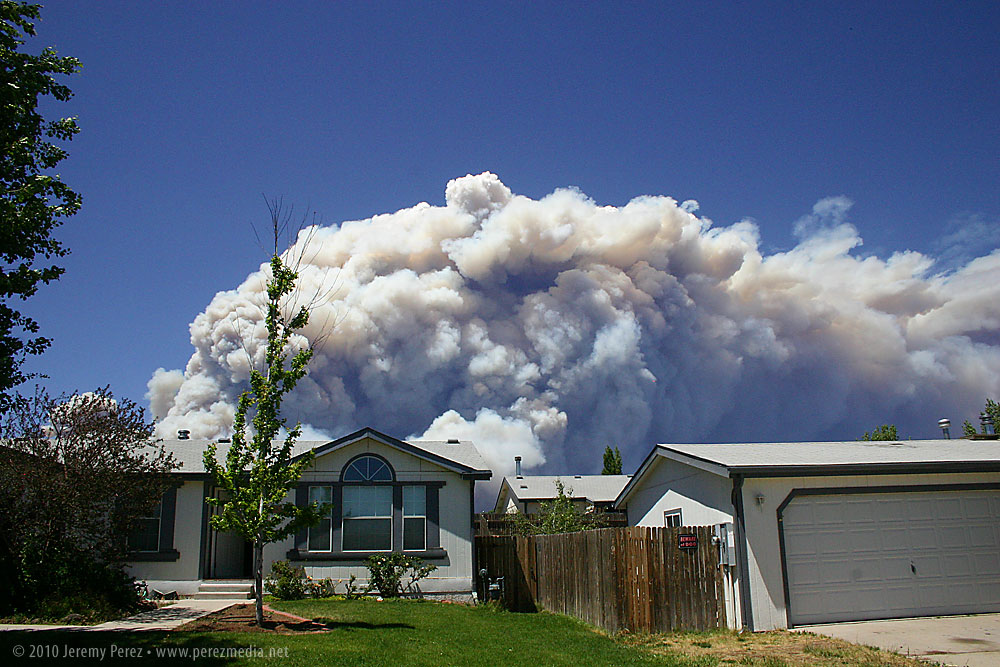
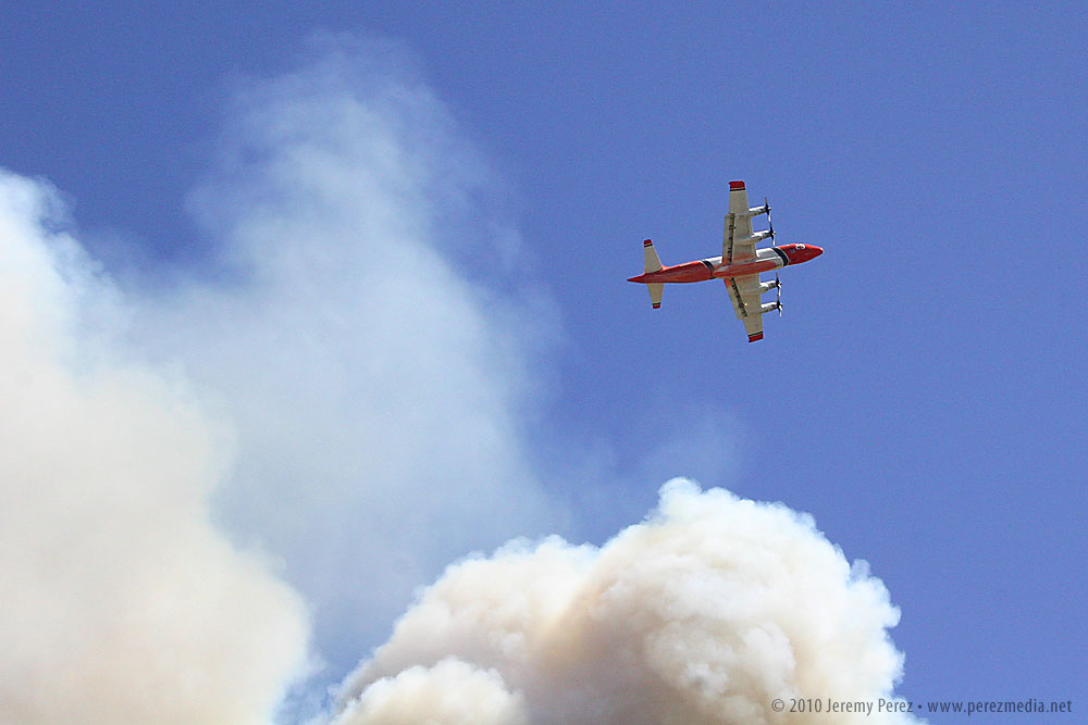
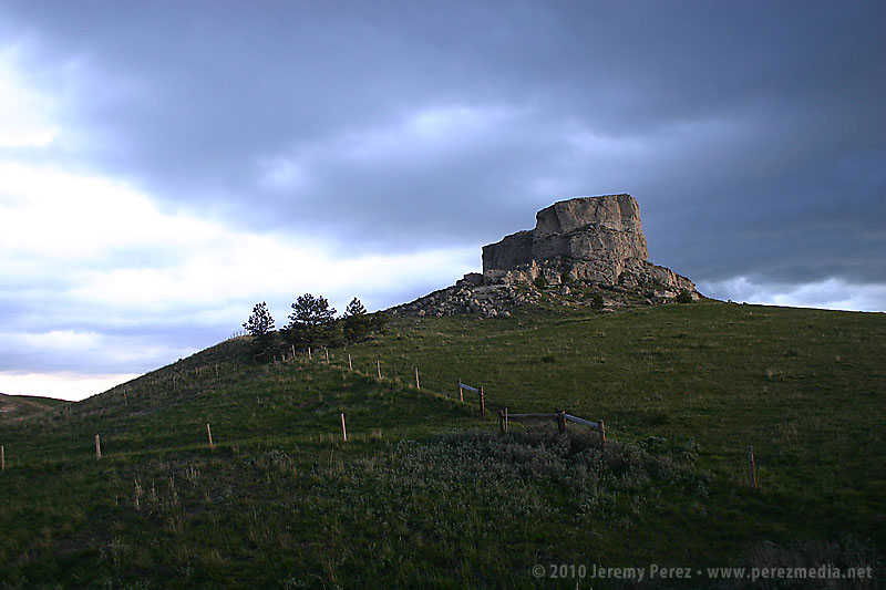
Schultz Fire - June 20, 2010
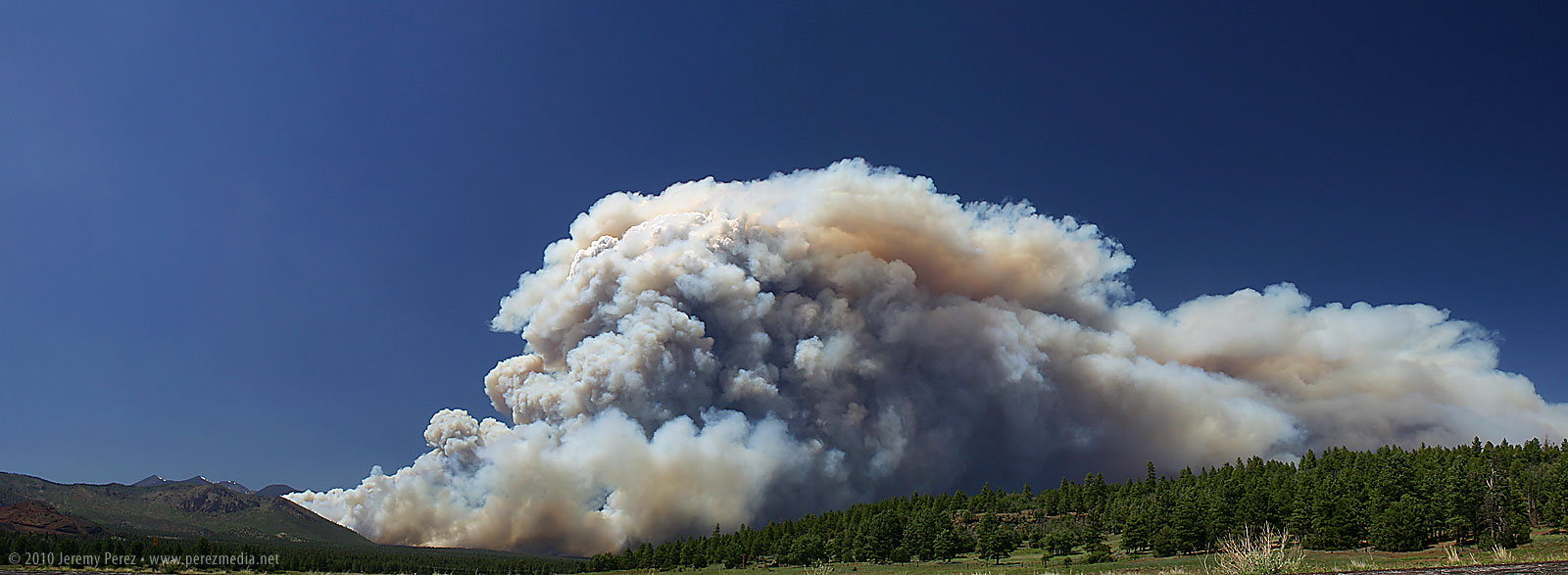
This one gave me a fright when I opened the kitchen window on the north side of our house this afternoon. For a couple seconds I thought that our summer monsoon had gotten a very unexpected start, but then I noticed the yellow and brown coloration and gasped at how close and large it was. The updraft was strong enough that it was pushing up a hedge of white pyrocumulus along the roiling top of the smoke column. Rather than clog up Highway 89 any further, we headed east along old Rt. 66 to get a vantage point near the Walnut Canyon overpass. We pulled of the road and watched the slurry bombers and helicopters drifted across the angry wall of smoke. I spent a few minutes shooting a time lapse of the breathing cloud of blue and brown smoke. Be sure to click the images for larger versions.
Schultz Fire erupts behind our house.
Schultz Fire Panorama from Rt. 66.
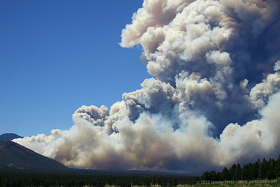
Close view of the base of the Schultz Fire.
Time lapse of the Schultz Fire. Select the 480px size for the best quality.
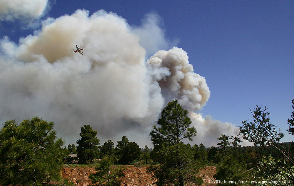
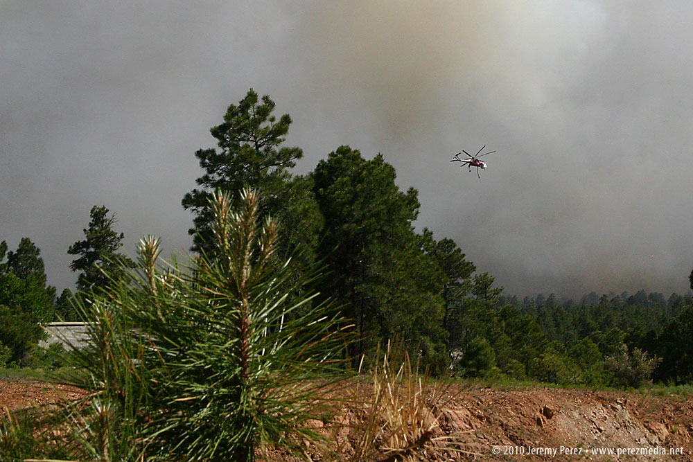
Hardy Fire - June 19, 2010
This one started yesterday, Saturday June 19, on the south side of town where it forced the evacuation of Little America Hotel and a few surrounding homes. I first noticed some white whisps of smoke shortly after lunchtime and within a couple hours it was shooting up a fierce smoke column. I drove to one of our office locations on 4th street to get some photos of the air tankers and helicopters orbiting the blaze. Click images for large versions.
Taking a Great Plains storm chase trip is something I've wanted to do for a long time. For the past couple years, I've been learning and practicing severe weather forecasting, and running some real-time virtual chases, but nothing can compare to getting on the road and actually doing it. So as May approached, I started keeping my eyes peeled for a good weekend setup.
Over the weekend of May 15/16, I noticed conditions favorable for severe weather might be shaping up for the following weekend, May 22/23. Low pressure was forecast to set up over the western US and spend several days sending impulses along very moist air across the central US. Upper air support, speed and directional shear all looked like they would provide support for tornadic supercells in varying locations.
As the week progressed, the GFS and eventually NAM forecast models continued to confirm this set-up, while timing and locations fluctuated from day to day. I got the o.k. to take Friday and Monday as vacation days, and planned to head for the Colorado/Wyoming/Nebraska borders on Friday, South Dakota/Nebraska on Saturday, and somewhere along the dryline from Nebraska to Oklahoma on Sunday. To get the best chance for current data on the road, I activated wireless broadband access with Verizon and got my forecast, satellite and radar links set up on the MacBook.
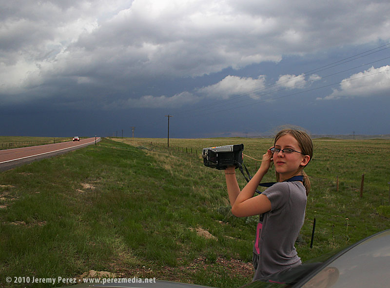
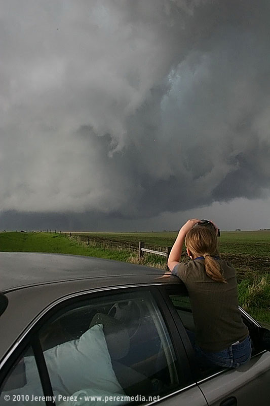
Giselle said she would like to join me, and the two of us took off Thursday night for what turned out to be a fantastic road trip. She ran the laptop and shot video so I could drive and snag photos.
Isn't that dangerous?
This is probably a good place to mention a few things about storm chasing and risks. I am not a big risk taker, but I'm not a shut-in either. Any time you set foot outside your door to enjoy some recreation, you face a spectrum of risk. Just strapping yourself into a car and hitting the road to take the kids to school seriously increases your odds of being injured or worse. How much hairier it gets obviously depends on how you approach what you're doing.
Because storm chasing is an unusual activity, the perception of danger can seem chilling. A tornadic storm is a dangerous beast. Increasingly, the media and Youtube have shown us that there are plenty of folks who either like the rush of going right up to the edge, intentionally counting coup with a tornado or who feel confident racing in front of it for good position and clear views. That is not the kind of experience I was after. I missed getting a clearer view of the Bowdle, SD tornado, and probably some interesting nighttime structure in Kansas because I wanted to keep my distance from the meso and it's intended path and because I wanted a nicely paved escape route and plenty of time to take it if the storm managed to make a 90 or 120 degree turn.
That's not to say I think the risk is zero, or that I would be immune from making a mistake, but the same is true of a lot of other outdoor activities that that take you away from your cozy living room and place you in the midst of the amazing natural world. I believe that by educating yourself and approaching the storms cautiously, it is possible to keep those risks to an acceptable level and to witness something that's truly awe-inspiring.
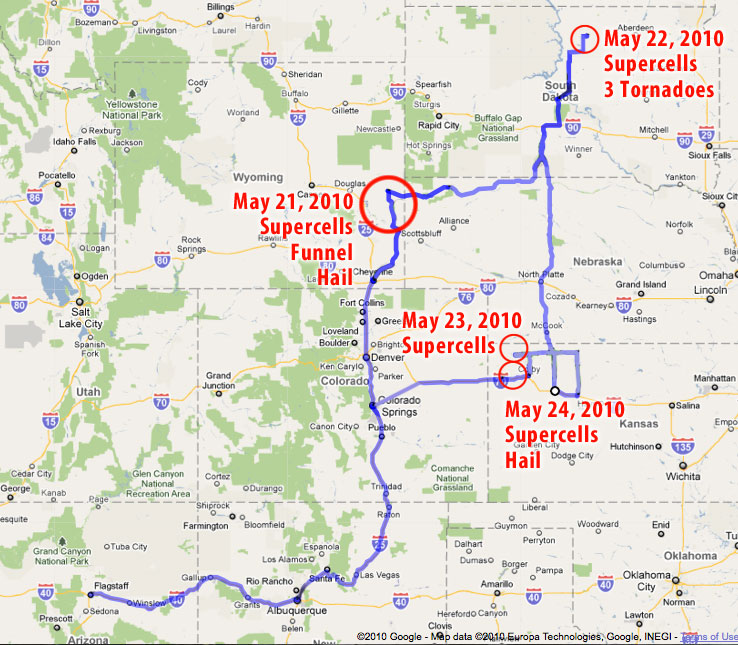
Click the links below for photos, video and details from each day:
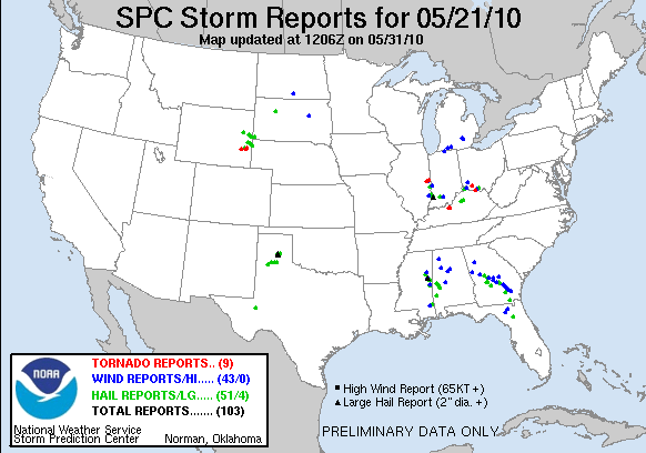
May 21 - Lingle-Lusk, Wyoming - Funnel Cloud, quarter-sized hail
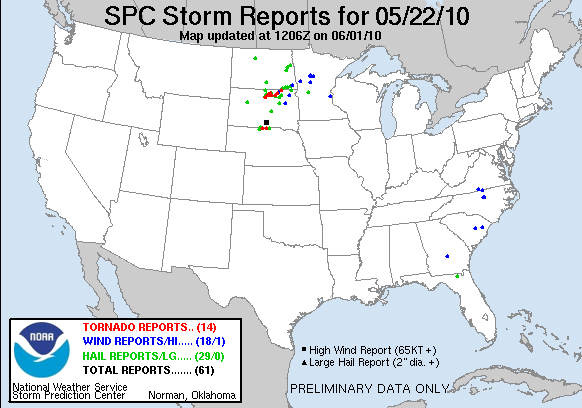
May 22 - Bowdle, South Dakota - 3 Tornadoes cycling from a single, intense mesocyclone
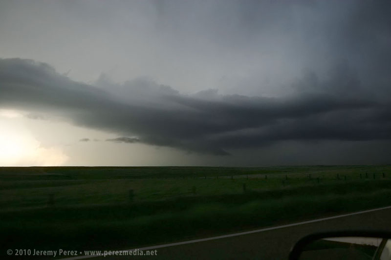
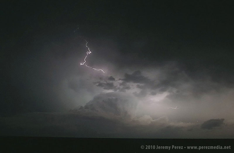
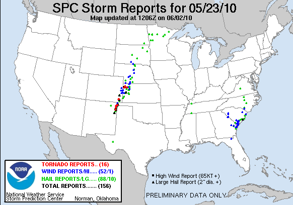
May 23 - McDonald, Kansas - Marble-sized hail and nighttime tornado-warned supercell light show
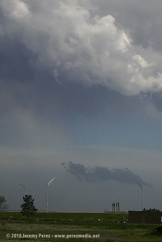
May 24 - Goodland, Kansas - Quarter-sized hail and mid-level shear funnel
On Thursday night, May 20, we took I-40 from Flagstaff to Albuquerque and then headed north on I-25. We grabbed sleep at rest stops and off ramps along the way. By noon, we were bogged down in traffic in the heart of Denver (what a mess). I figure we lost about an hour trying to pierce the heart of the city instead of taking one of the outside routes.
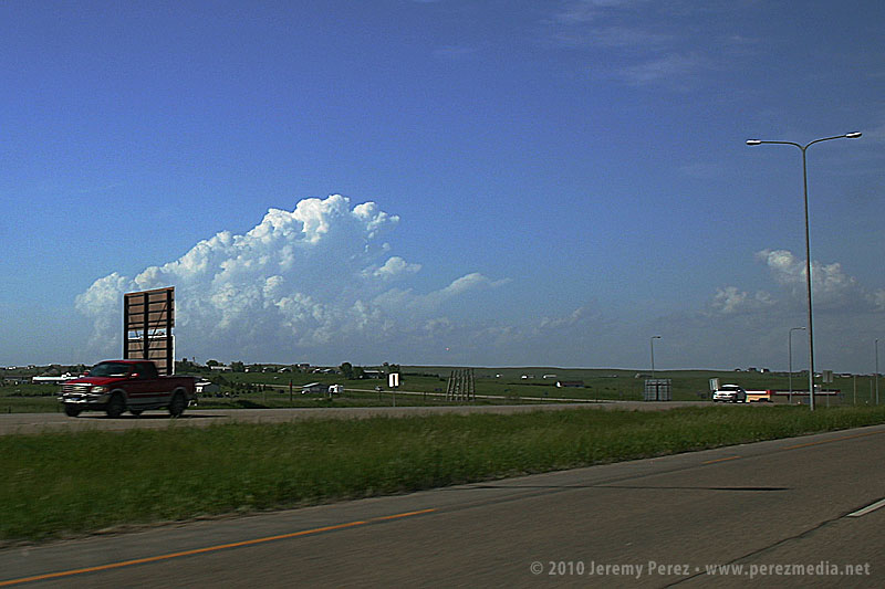
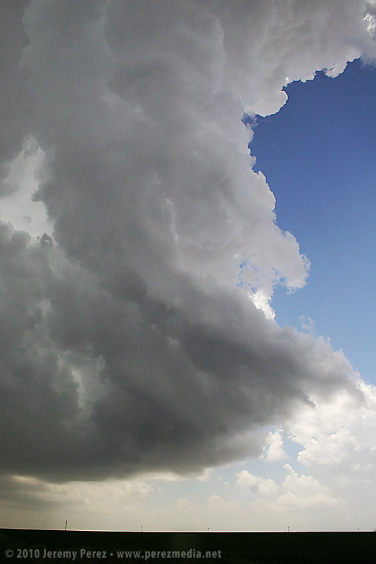
North of the city, we had a bite to eat at Wendy's while strongly sheared cumulus tried to pierce the CAP along the front range. The tough part was trying to decide where initiation would take off. Decent CAPE, shear, and a frontal boundary were setting up in southeast Wyoming, so we got back on I-25 and headed north. As we approached Cheyenne, Wyoming, radar showed cells getting healthy along I-25, further north near Wheatland. One cell pulled its act together and started peeling away to the east-northeast. In an attempt to parallel and get ahead from the south, we broke northeast on Hwy 85 toward Torrington and Lingle.
As we approached Torrington, the supercell dominated the sky to the north like a great hen roosting over her clutch with features gradually resolving along the base.
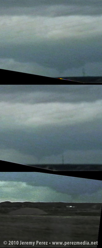
As we entered Torrington and headed toward Lingle on US-85, trees and buildings demolished our view, however, upon clearing some trees about 00Z, we got a sudden and stunning view of a wall cloud and what appeared to be a funnel silhouetted to the northwest. When in silhouette, it's not possible to determine rotation, so at the time, all we could do was film it and see if we could catch up.
Video frame grabs:
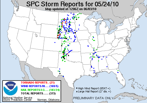
The SPC report later confirmed two tornado touchdowns northwest of Lingle at 23:55Z and 00:01Z. So I'm confident that the feature we saw was indeed a funnel--whether it was a tornado at the time we saw and filmed it, I couldn't say.
We took US-85 north of Lingle, and caught fractured glimpses of the disintegrating wall cloud between otherwise stunning, hilly terrain. When we finally caught up to it, the wall cloud was gone, although the base was still slowly rotating. A deep, turquoise light emerged from within.
Road options were seriously limited, so we couldn't follow this one as it tracked to the northeast. So we continued north on US-85 as other storms erupted.
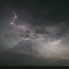
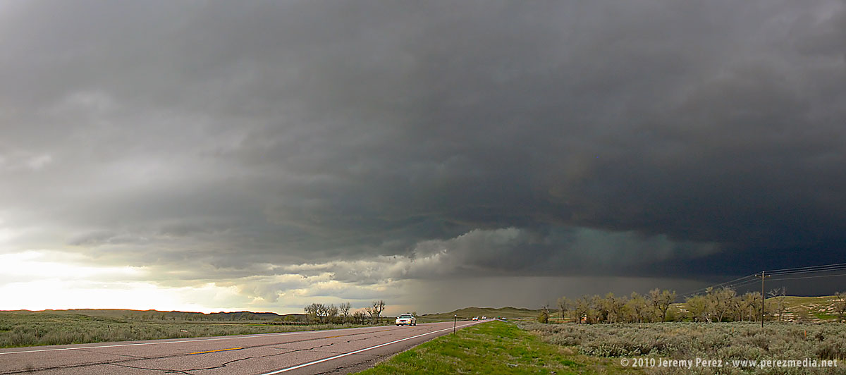
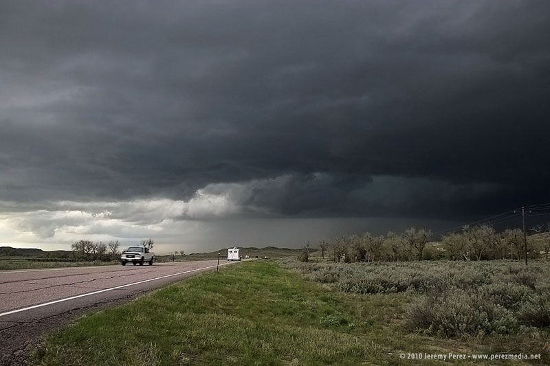
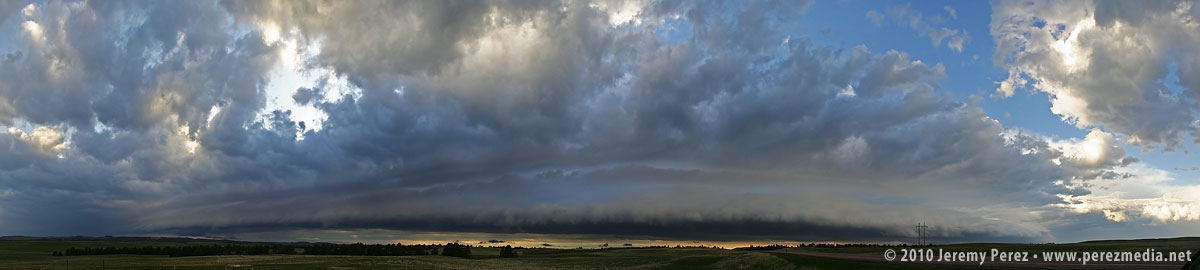
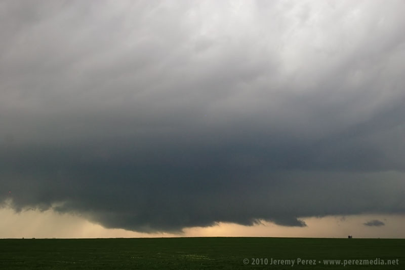
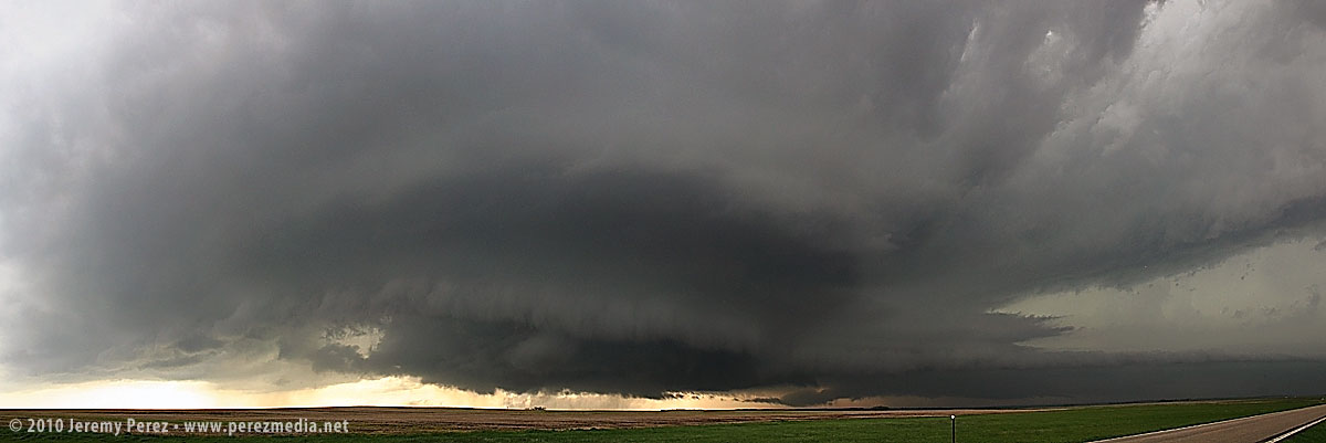
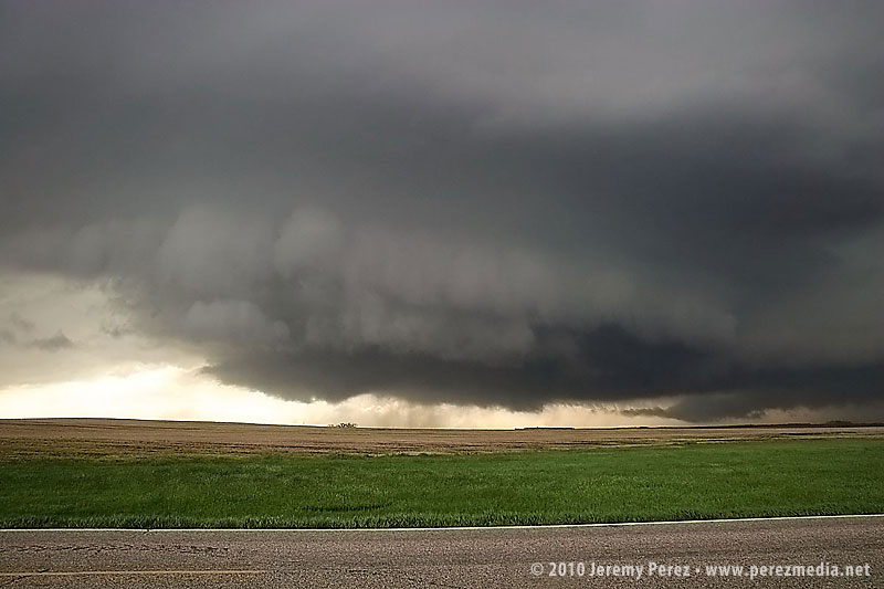
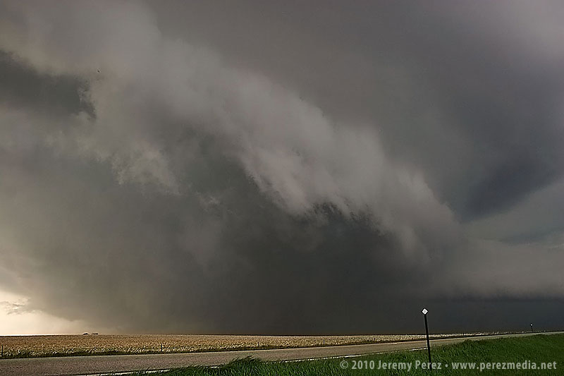
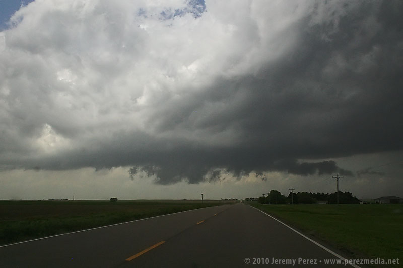
North of Lusk on US-85, we drove beneath an enormous, beautifully lit shelf cloud.
This time lapse video shows motion of the shelf cloud and lowered inflow base:
Illumination beneath this storm was surreal and bathed the Wyoming landscape with a dream-like light.
After nightfall, we spent some time in Lusk, looking for a good place to stay the night and getting pelted with nickel and some quarter sized hail. Every room in Lusk was taken, so we drove on to Chadron, Nebraska and tried to rest up for our next day in South Dakota.
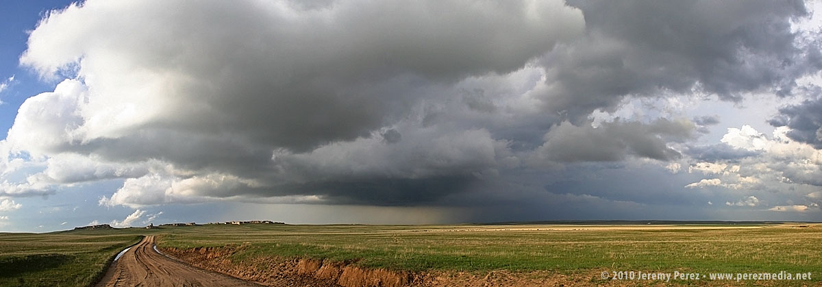
When we checked out of the hotel in Chadron Saturday morning, we had no idea what an incredible day this would be. Forecast models showed the triple point positioned across north central South Dakota by afternoon with ample moisture, huge CAPE, and shear favorable for tornadic supercells. It looked as if there was hope that the CAP would erode well enough to allow things to reach their potential.
Our first destination was Pierre, SD. When we arrived, I tried to find a book store where I could pick up a DeLORME South Dakota Atlas, but we were foiled. The manager at one book store said "we really don't have that many roads in South Dakota"...heheh. Cumulus were beginning to fire to the north-northwest and we couldn't waste any more time tracking one down. So we had to rely on our single-page Rand McNally map which gives no clues about local and farm roads.
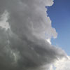
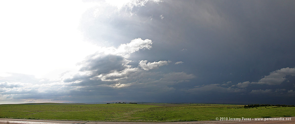
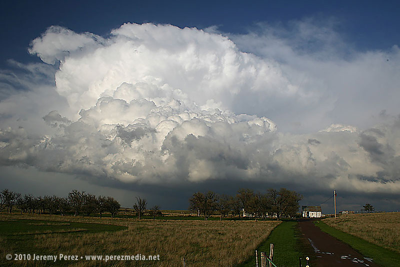
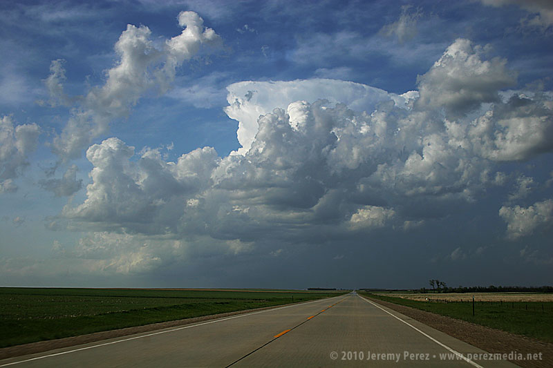
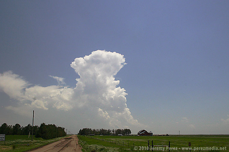
As we headed north on US-83 at 2140Z, the cumulus field was starting to pull itself together and definitely looked like it was going to beat the CAP.
It was exciting to watch it grow and to realize that we were going to be in good position to intercept if it did explode. And it did! By 2215Z, it was pushing up a firm anvil, and by 2235, it was straight ahead, sporting robust inflow bands.
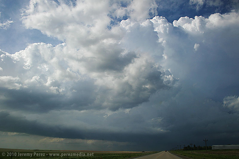
Features under the base began to lower and take shape as we approached the junction with SD-20 where we headed east to gain more ground on the storm.
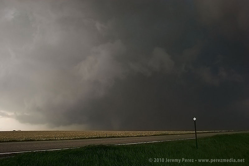
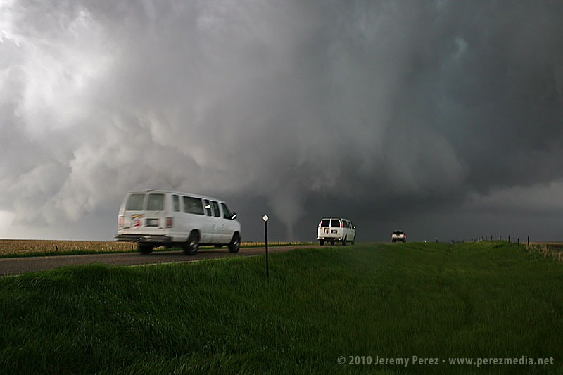
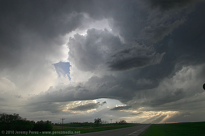
Thirteen miles to the east, we turned back north on SD-47 and by 2300Z, we were watching a foaming wall cloud being fed by a well-defined beaver tail.
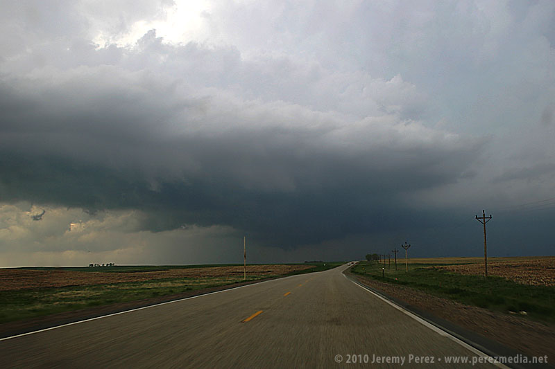
It's difficult to describe the sense of anticipation as we drew close to the point where it would cross the road. I'm not a danger-junkie, and did not want to set up where we would find ourselves beneath the mesocyclone. But I didn't want to position so far away that we couldn't see the churning details that were resolving better and better as the storm approached. We found a pullout and backed in (safely) so we could drive back out and reposition if needed.
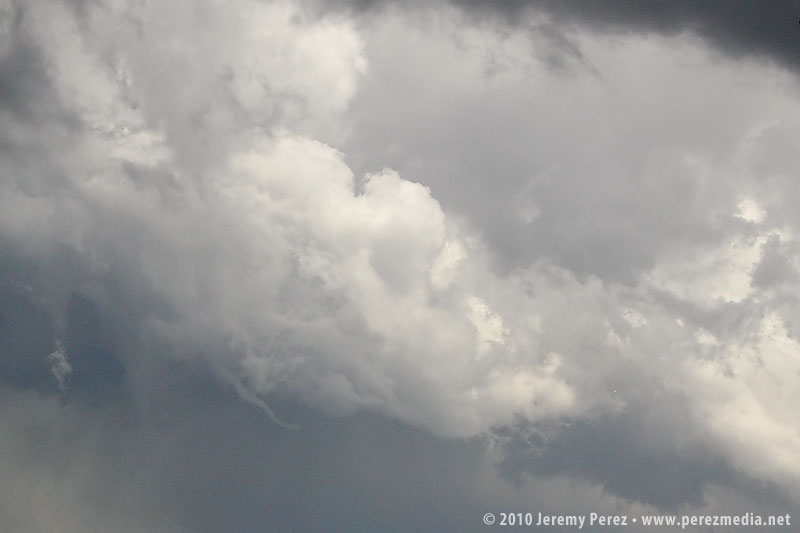
As the meso approached, warm humid wind pushed hard against our backs, urging us to surrender to the storm's gaping appetite. A golden light seeped beneath the base and RFD began to stir up ragged masses of dust on the far side like a cage going up around the ring. The array of rising, rotating, intertwining structures had me completely awestruck--it made me think of a Grand Design spiral galaxy in fast motion, the monster at its core threatening to burst to life.
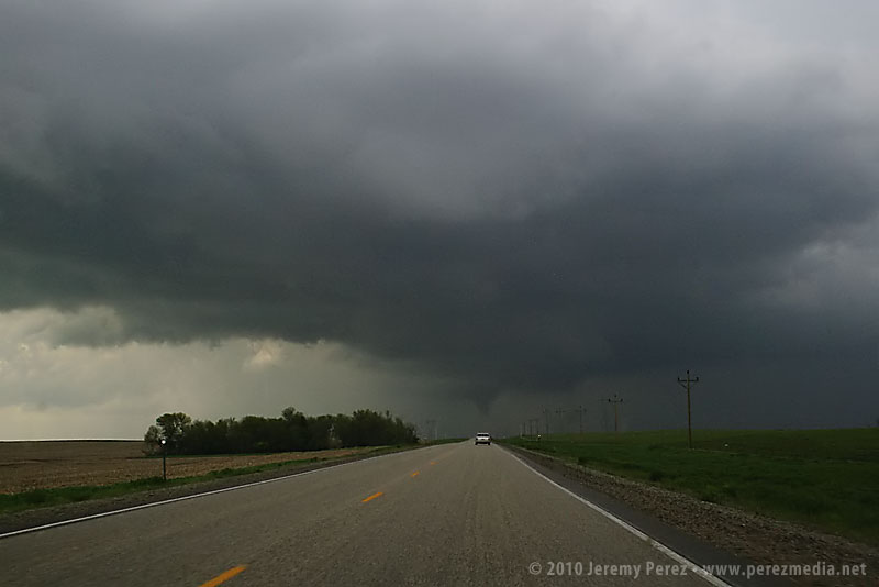
While the heart of the meso was on track to pass north of us, the growing rim of the toothy RFD shelf looked like it was going to pass too close for my sensibilities, so we buckled in and headed south. As we drove, the south side of the meso began to drop and tighten up--things were getting ready to happen before our eyes. We found another pull out about a half mile further south and watched as rain wrapped under the base, while the RFD shelf arced onward.
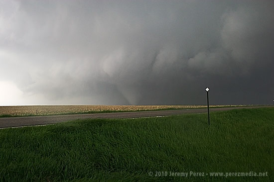
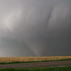
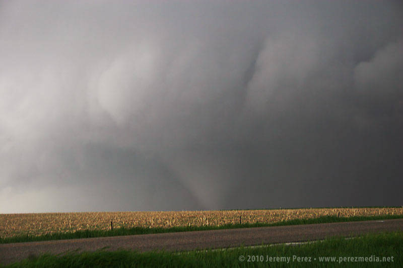
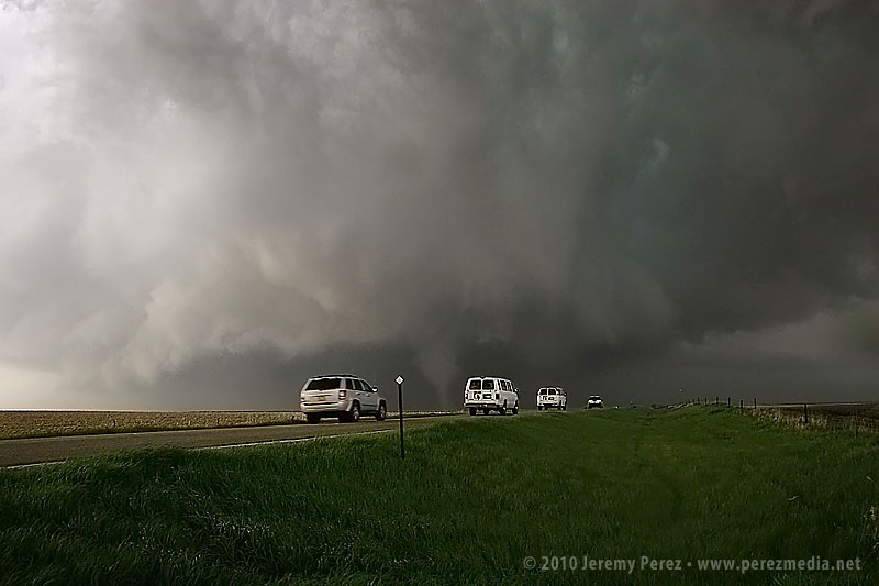
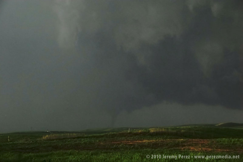
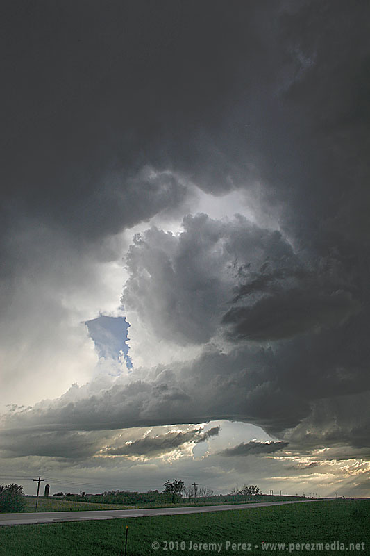
As the mist of precipitation cleared, the hulking mass of a wide cone-shaped funnel emerged from the shadows of its wall cloud (2315Z).
As it slowly moved from left to right, the cone got fatter and then slowly pulled upward, a pale uvula drooping from the singing mouth of the storm.
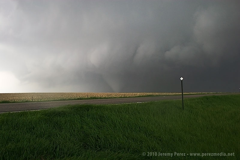
At 2317Z, the bulbous funnel formed a ground churning tip, like a hypodermic needle inoculating the earth. Within seconds, it had finished sampling the farmland and began to degrade into a ragged finger that faded into another curtain of mist. By the time the meso crossed the road (2319Z), the condensation funnel was all but invisible.
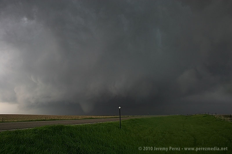
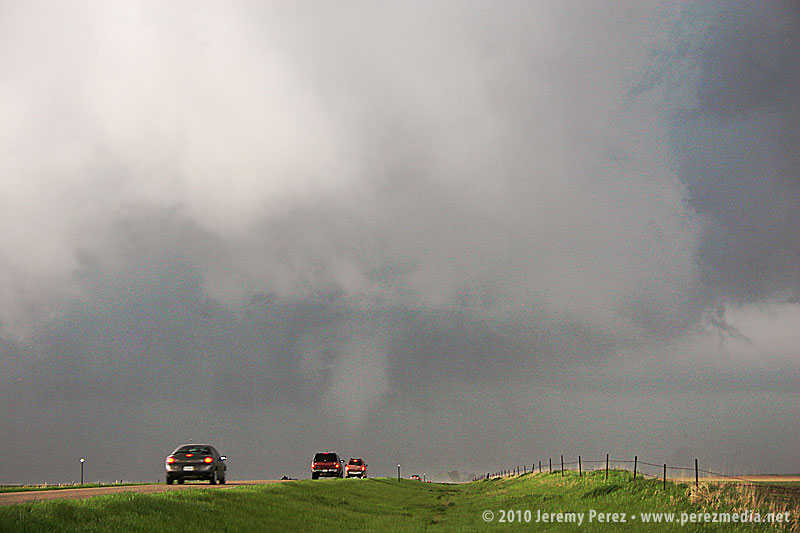
A minute later at 2320Z, the flying curtains of rain parted to reveal a second tornado planted firmly to the ground on the other side of the road. Chasers positioned northeast of the storm confirm that this tornado dropped from a second area of circulation beneath the meso while the first one dissipated.
As the tornado disappeared into the rain and the storm receded, we got back in the car and headed north on SD-47 to find a leaning power pole and vehicles blocking the road where the tornado crossed. As we prepared to turn around, the TIV rolled by heading south. It will be interesting to see whether they made a successful intercept.
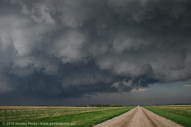
We spent the next 30 minutes looking for another north option by way of gravel/dirt farm roads. We followed a tour van at a hopefully respectable distance on the chance they could locate another north-south access to US-12. As we drove, the extended gust front of the supercell roiled overhead like the unkempt fur of a great hairy beast.
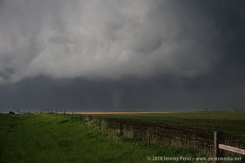
Since we were behind and south of the storm and the roads were dry, I wasn't concerned about getting stuck in a precarious position, but I was a little frustrated that we were going to lose it. It turns out that while we were rumbling down these roads, the storm had developed a huge wedge and was tearing things up just north of Bowdle. At 2351Z, we reached a high point that allowed one last look at our third tornado of the day. The distant, silhouetted elephant trunk appeared for mere seconds before disappearing behind more rain.
We finally reached US-12 just south of Bowdle and paced eastward. We followed a ragged, brightly lit mass of rain and rotating scud that may have belonged to another inflow region that was forming south of the main cell. We shot photos and video along the way until we were stopped by emergency management vehicles at the junction of US-12 and US-253 at 0032Z.
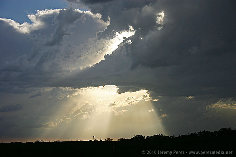
After shooting some more photos, we turned around and headed back toward Pierre. On the way back, we were treated to gorgeous views of other cells soaring into the fertile sky.
Although it would have been nice to have positioned ourselves to see the wedge and multivortex tornado that this storm produced, we were extremely excited to have seen such an indescribably powerful and stunning event on our second day of chasing. We drove back to Pierre, worn out and hoping for another great day in Kansas on Sunday.
Day 3 in Kansas was a bit of a bust for us. As we drove south through Nebraska, we found ourselves behind the TIV crew as the dryline was beginning to brew in western Kansas/Eastern Colorado.
As we dropped south toward Hoxie, Kansas, cells were beginning to go severe. We noticed a caravan of chasers heading west toward Colby. However, a couple frames of radar convinced me not to head west, but to continue south and then east in hopes of heading off a storm that I thought was turning right. It was a huge mistake. Shortly after that last radar loop, the cell I was watching was consumed by another to its west. From then on all storms that exploded along the dryline raced almost directly north at 40 to 50 mph. By then, I had placed us 75 miles too far to the east. Soooo stupid. Meanwhile spotters were reporting tornadoes along the dryline, screaming northward. I tried to salvage the situation, heading north and west to try and catch something--anything, but it was too late. By the time we reached the conveyor belt near Atwood, the sun was setting, and it was getting to hazardous to intercept.
So we hung out on US-36 listening to radio reports and catching radar whenever we could get a connection. As night fell, a couple tornado warned supercells lit up the sky, moving up from south. As the storms crossed north of our road, we had a clear view of their structure as they were almost continuously illuminated by lightning.
Although we missed out on any tornadoes, I learned some lessons about forecasting storm motion, and being cautious about how much I bet a sizable drive away from the boundary on just a couple frames of radar. And we did get a stunning light show to cap the day.
The original plan was to spend day 4 driving home, but an early start to some severe storms tempted me to stay a while and practice intercepting along roads near Goodland, Kansas. The first severe-warned storm we intercepted sported a weak, ragged lowering beneath the base.
Over the next couple hours, other storms popped along the dryline and raced north where we positioned and waited for them to pass. One cell was severe warned as it approached our position, and we had a gorgeous view of its corkscrewing tower as it began to toss marble, then nickle, then quarter sized hail at our car. It's a thing to experience, but enough was enough, and we pulled onto the shoulder beneath an overpass to wait for the bigger chunks to subside.
We caught a couple more storms before leaving--one of which sported a persistent mid-level shear funnel. Overall it was an enjoyable end to our chase trip. We got a few more photos and regrettably a few dimples in the hood and roof of the car as a reminder of all the powerful storms we saw.