As the Spring severe weather season rolls around, I like to work out the kinks in my forecasting and chasing strategy by running virtual chases on a few select days with severe potential. I'll pick a target area for the morning of, drop a pin in Google maps, check conditions as the day progresses, and adjust my position, then commit to a storm and use the map time estimates to see if I can be in position for a supercell and possible tornadoes.
Taylor Campbell is a chaser who has set up a website called 'Storm Chase Game' at stormchasegame.com. The damage that severe storms cause is no game. However, the format of the site seems like good practice for chasers trying to gear up and stay in practice for forecasting during severe storm season. A little competition can help take the process seriously and commit to a forecast and target area. Unfortunately, you can't adjust position during the day as you normally would while chasing, but that would probably be impossible to manage for that kind of format. Anyway, I've got an account there and have virtual chased a couple setups near the north-central Oklahoma border with Kansas on April 2 and northwest Arkansas on April 3. I picked up some severe hail and wind reports on those, but no tornado reports.
I figured, if I can keep up with it, I'll post my abbreviated forecast and positions here and whether it panned out.
So for tomorrow: April 13, 2014
A triple point is forecast to set up in western Oklahoma and drag a dryline eastward over the course of the afternoon while a cold front drops in from Kansas. The dryline looks to stay intact during peak heating and convection development before the cold front mashes it into linear storms during the evening.
I'm positioning at Sapulpa, Oklahoma, southwest of Tulsa. Timing of shortwave energy will be crucial. This is a compromise between NAM and GFS. I will be positioning east of triple point for where there is likely to be better directional shear as convection erupts and prior to arrival of cold front. Bulk shear will hinge on the shortwave and could range from 30-45 kts in this area. NAM is forecasting 0-1km SRH around 175 m^2/s^2 ahead of storms moving through from 21-00Z with CAPE values from 2000-2500 j/kg. Normally, I wouldn't chase this area due to terrain and urban environment. Hoping people in eastern Oklahoma stay tuned to weather radio/TV tomorrow and get to shelter if tornado-warned storms move through in the afternoon/evening.
[Edit:]
With more recent runs of NAM, the cold front is proceeding further south during the afternoon and better instability also further south. Revised my position south west of the original location to Prague, Oklahoma.
Results:
Nearest Tornado Report: 130 miles SW
Nearest Severe Report: 13 miles SSE [1 Inch Hail]
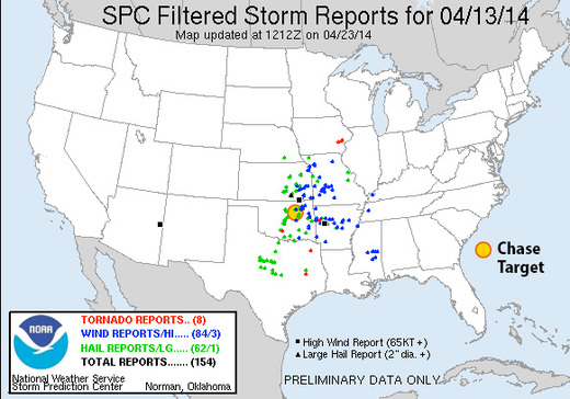
I'm pretty easily deceived by what I think I see happening on model forecasts vs. what actually takes place when it comes to cold front interference...as in how fast it moved through and lined out storms in northern two-thirds of Oklahoma. Morning convection forecasts also showed better chances of convection along the dryline into north Texas. If I had actually engaged in the misery of chasing eastern Oklahoma, those AM model runs, plus this satellite view would have sent me south of my original target:
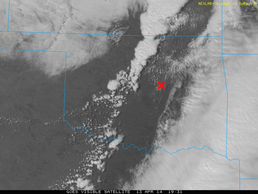
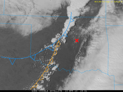
Despite foiling my theory for chase targeting for the day, I think that satellite view is awesome. Once midday heating and convergence gets going, the boundaries start to get marked out by cumulus. This is a great view of the cold front rushing southward and overtaking the dryline while strengthening convection zippers southward along the cold front. More isolated storms eventually got going further south along the dryline where the cold front wasn't messing things up as early, with a tornado report about 18 miles east of Duncan, OK. Besides a couple tornado reports in Iowa and east Texas, that was it for tornadoes. I did pick up a few hail reports inside my game radius, but not the part of the setup I was after.
