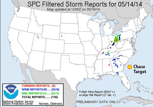
Chase Target: Zanesville, Ohio
I'm relying on guidance from NAM for this forecast and have run out of time to compare with GFS.
A surface low will be consolidating over western kentucky as afternoon progresses. A warm front will be established northeast of the low through southern Indiana, and northern Ohio. A cold front will nudge into western Kentucky/Tennessee and eastern Mississippi. Mid 60 dew points will advect into the warm sector. CAPE values of 1500 j/kg reside from central Kentucky northeastward across southeastern half of Ohio and western Pennsylvania while a pocket of 2000+ j/kg resides over southern Ohio during the afternoon.
Mid level jet placing 40-50 kts of bulk shear over boundaries with enough extending over the warm side to affect convection. Strong 0-1 km SRH resides mainly north of the boundaries, but stronger pockets develop over western Kentucky during early afternoon, and 100+ m2/s2 over southeastern Ohio toward 00Z. Convection is forecast to be ongoing and messy throughout the day, so it's difficult to for me to anticipate how that plays out in this area. My target is in southeast Ohio where 0-1km EHI rises over 1.5 by 00Z and the lid strength index points to wide openings for surface based storms in the area.
Results
Nearest Tornado Report: 94 Miles West-southwest
Nearest Severe Report: 3 Miles Southeast [Hail: 1.5 inch]