It's been three years since I've had a really good storm chase in Arizona. This past Saturday, I had a chance to make up for the last couple of missed years. I wound up tracking three supercells along Highway 93 between I-40 and Wickenburg. The last of those three was difficult to observe due to bad positioning, surrounding convection, and unexpected freight trains, but the first two were spectacular amid some stunning Arizona landscapes.
The day before, I had set an initial target of Kingman, Arizona by sunrise, based on NAM and GFS placement of a closed low over Nevada. This was forecast to wrap up 30-50 kts of deep layer shear on top of a cold front over the Colorado river while rich moisture surged northward bringing mid 60 degree dew points. As is usually the case, targeting was based on a compromise between better instability further south vs. better dynamics further north. Instability and backed surface winds appeared to be maximized around daybreak and weakening by midday (1000-1500 j/kg with 100-150 m2/s2 SRH). By the night before, all models were trending downward on lapse rates, so forecast instability was dwindling. However, there was still enough to work with, and hodographs were very tantalizing by Arizona standards. This did adjust my perspective on positioning and timing. So I was able to get a bit more sleep and head out of Flagstaff a little later than planned (5AM instead of 3AM).
I stopped at Seligman about 6:00 AM. As I looked west, I was treated to a line of storms flickering with constant lightning as they trained along the cold front near Kingman. HRRR was forecasting the convection to quickly fill in eastward, along sheared out bands with some stronger embedded storms. HRRR's version of SRH, bulk shear and CAPE still looked promising and was trending toward batches of storm helicity tracks over western Yavapai county by mid to late morning.
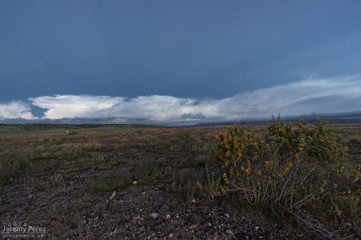
Anticrepuscular rays lead into a line of storms as seen looking west from Seligman, AZ. 6:05 AM / 1305Z
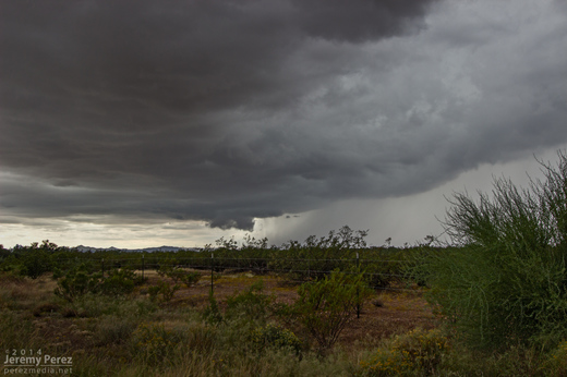
Once I reached Highway 93 a little before 8AM, a weak line of storms was passing overhead while a stronger line was approaching from the west. That stronger line featured a healthy cell just to my southwest with a persistent velocity couplet. It looked like it would cross Hwy 93 a couple miles south of I-40 and I had some difficulty deciding on which highway to intercept it (no decent side-road options in this area, just the two main perpendicular highways). I would have preferred the east-west option of I-40 for more fine-tuned positioning and safety margin on storms that are moving mainly northward. But I finally decided on my north-south Hwy 93 option since it would give more opportunities to pull off, start and stop instead of being trapped on the interstate with fewer offramps. As the updraft for the embedded cell moved by my position, it wasn't much to look at, and just seemed to be putting a bit of a kink in the line.
Updraft base in a line of convection as seen looking west from Highway 93 about six miles south of I-40. 8:10 AM / 1510Z
A line of convection as seen looking west from Highway 93 about six miles south of I-40. 8:30 AM / 1530Z
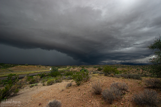
A supercell sports a lowering where the highway disappears into the hills. Meanwhile, trailing convection begins to merge into a bowing segment. View is to the northwest from Highway 93 a few miles south of I-40. 8:35 AM / 1535Z
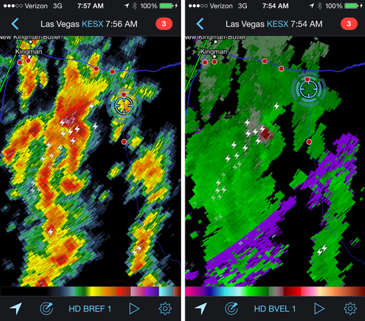
Reflectivity and velocity radar of the embedded mesocyclone. 7:54 AM / 1454Z
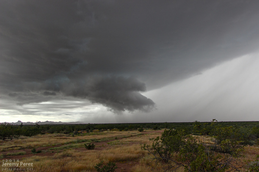
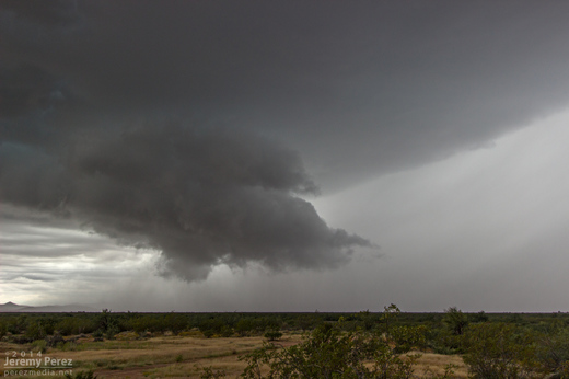
Because of the added safety cautions being on the north-south road, and new convection fluctuating to the south of my target cell, I decided to stay a lot further south of it than I wanted. About the time it neared the I-40/Hwy 89 junction, it didn't look as strong on radar, but the trailing gust front finally pushed hard and it expanded outward in spectacular fashion. As a kink in the shelf took shape, a rugged, conical lowering materialized behind the surging gust front before getting smeared out.
The gust front south of a supercell pushes out over Highway 93 a few miles south of I-40. View is to the north. 8:40 AM / 1540Z
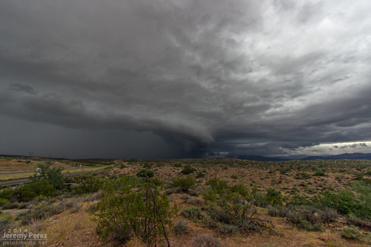
A kink in the gust front develops, leading to a conical lowering. View is to the north from Highway 93. 8:40 AM / 1540Z
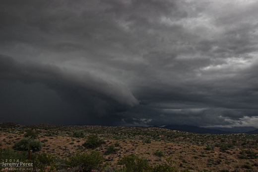
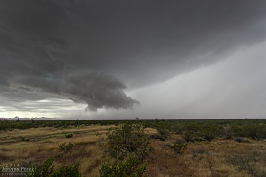
A shelf cloud lines up along Highway 93. View is to the north. 8:45 AM / 1545Z
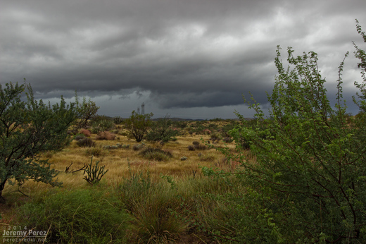
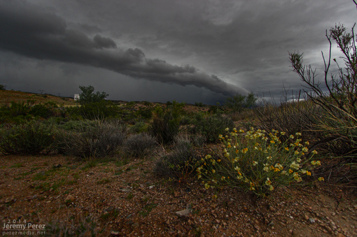
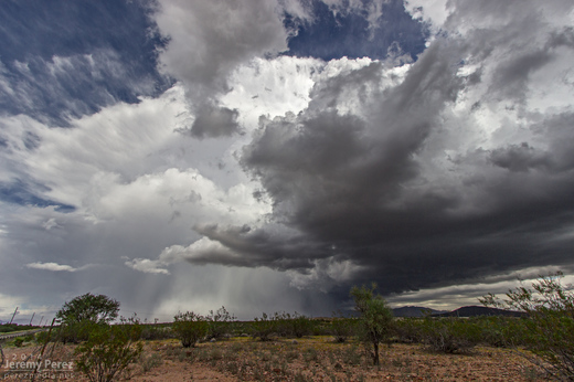
After that amazing encounter, I headed further south to get in front of some more developing convection. Along the way, I caught brief views of stronger updraft bases between precipitation cores, and irresistible stormy views in the desert terrain.
A dark rain free base peeks out from between two rain cores as seen from Highway 93 looking southwest. 9:50 AM / 1650Z
Disorganized convection paints the sky above a soaked desert landscape. As seen from Highway 93 looking southeast. 10:20 AM / 1720Z
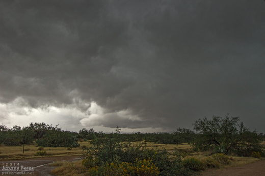
By this time, HRRR was trending toward better options further east into central Yavapai county. So I headed east to Congress when a strong cell with a developing couplet started moving in from the southwest, so I headed back south toward Wickenburg on Highway 89. As I cleared heavy rain on some cells popping up overhead, the base of the Wickenburg storm came into view. It was sporting a lowering and a huge tuft of scud was rising up from the ground to meet it. As that merged with the rain free base, the storm had the embryo of a wall cloud.
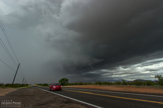
A wall cloud begins to form beside the forward flank of an approaching supercell. As seen from Highway 89 between Wickenburg and Congress looking southwest. 11:25 AM / 1825Z
While photographing it, I noticed that the storm appeared to be deviating a bit to the right. So I jumped back in the car and headed further south to avoid getting cut off. During that short drive, the wall could got sturdier as it made attempts at a tail cloud along the interface of a the forward flank. It reminded me a lot of another beautiful supercell I intercepted in Wyoming back in May.
Wall cloud on a supercell north of Wickenburg. As seen from Highway 89 facing southwest. 11:30 AM / 1830Z
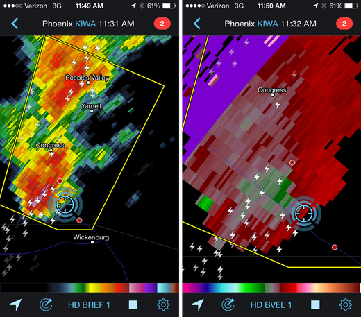
Reflectivity and velocity radar of the Wickenburg supercell. 11:32 AM / 1832Z
I was so busy trying to coordinate video and photography, and keeping track of overall storm motion that I couldn't relax and see if any slow rotation was present. At this point, if there was any rotation in the wall cloud, it wasn't fast enough to make me think it was about to plant something out in the mesquite and palo verdes. However what was concerning is that the storm was turning even further to the right and I had to hustle out of the way. As I raced south, I started getting shoved around by RFD that was starting to fill in with rain. Once I was clear, I got view of the back of the RFD core and right edge of the wall cloud as it moved away.
RFD partially obscures the rotating wall cloud on a receding supercell between Wickenburg and Congress. As seen from Highway 89 looking north-northeast. 11:35 AM / 1835Z
I still wasn't confident if I was seeing low level rotation, but I did call it in to the Phoenix NWS office as exhibiting supercell structure. Looking at the video and time lapse sequences later, it definitely was twirling behind the RFD. The view of the entire cell moving away over the desert was incredible. The dark base and flanking line contrasted against the bright white RFD core and anvil against a deep blue sky. It was spectacular.
A receding supercell thunderstorm dumps rain and hail over Congress, AZ. As seen from Highway 89 looking north-northeast. 11:45 AM / 1845Z
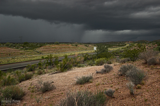
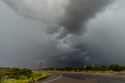
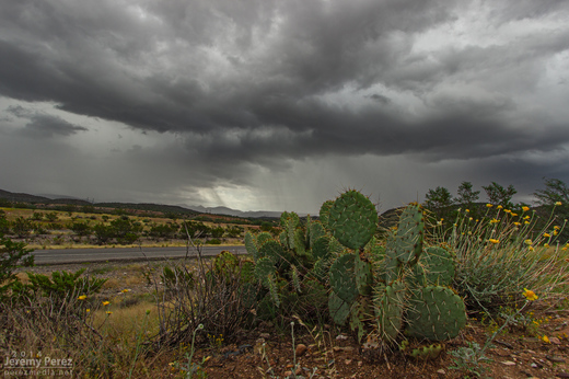
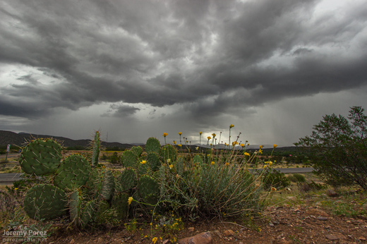
After savoring the experience, I had a choice between more cells moving into Yavapai County, or a building squall line moving into Phoenix. I was feeling a little hooked on the supercell storm mode, so I didn't head into Phoenix for the amazing show that storm put on. Instead, I repositioned west of Congress for the next line of storms as another cell with a velocity couplet was moving in. Unfortunately, it was surrounded by more developing convection and I only had brief views of structure between morphing rain cores. I was about to make a hopefully decent intercept, but was stopped short as a freight train took its sweet time blocking my best approach.
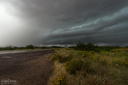
A striated shelf cloud approaches the intersection of Highway 93 and 71. The rain free base on this supercell was obscured by surrounding precipitation. View is to the southwest. 1:05 PM / 2005Z
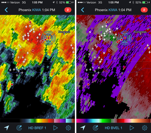
Reflectivity and velocity radar of broad circulation in a passing storm. 1:04 PM / 2004Z
A new updraft base forms to the south of a passing supercell as seen from Highway 71 in Congress, AZ. View is to the southwest. 1:15 PM / 2015Z
Once that storm was gone, I decided to take the scenic route back toward I-17 and took Highway 89 to Prescott. The long drive up the mountain switchbacks took me into the dark of the foggy cloud bases where mounds of small hail still survived in places against an onslaught of heavy rain. As I descended the east side of the mountain range I came across several sections of road that had recently seen flooding and had to stop at one point to pull an 8-inch diameter log out of the road while essentially taking a full on shower.
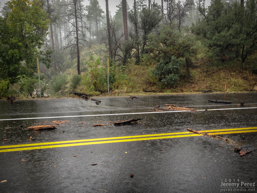
Flash flood debris on Highway 89 just south of Prescott (Had already pulled the huge log out of the road at this point). 2:56 PM / 2156Z
As I made my way into Prescott, DPS was roaming around pulling debris out of the streets. Further in, I passed a storm drain that was fountaining water, and the town was a waterlogged, debris strewn mess. The worst had passed though, and there were no 'turn around don't drown' scenarios to deal with.
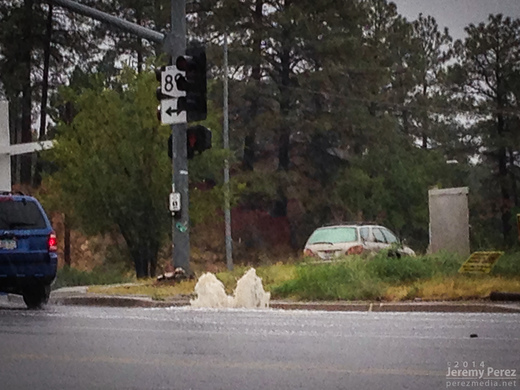
Overloaded storm drain in Prescott. 3:04 PM / 2204Z
As I made my way up I-17 back to Flagstaff, I skirted the west edge of the weakening line of storms and noticed an eddy on radar moving over east Flagstaff. Looks like this might have been a bookend vortex on the line. I wish I could have seen what that looked like, but that will have to wait for another time.
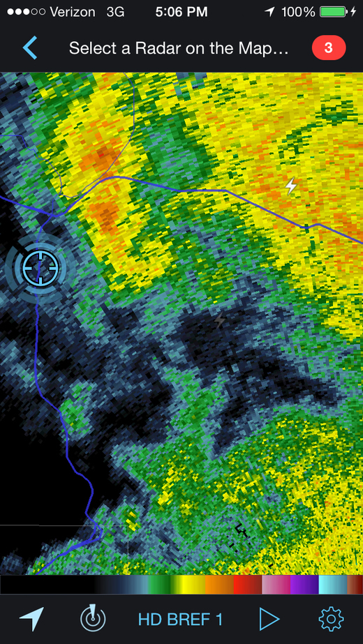
Reflectivity radar of possible bookend vortex southeast of Flagstaff. 5:06 PM / 0006Z
What an amazing chase. No tornadoes, but three Arizona supercells in one chase day is so much better than I could have hoped for. It has me seriously itching for springtime in the Plains—only 6 or 7 months to go!
Arizona Storm Chase and Supercells - September 27, 2014 from Jeremy Perez on Vimeo.
Video account and time lapse sequences from the chase.
