Chase Target: Coldwater, Kansas
A dryline reaching northward from the eastern panhandles will be the focus of convection starting possibly around 21Z. Bulk shear is forecast to increase to around 50kts into late afternoon, early evening along the dryline from the eastern Texas Panhandle into west central Kansas. CAPE will reach up to 2000 j/kg in this area. 0-1km helicity may reach 100 m^2/s^2 during the afternoon, and jump over 200 by sunset. LCLs will be high with inverted-V Skew-T profiles, so high-based storms with a tendency toward gusting out and reduced likelihood of tornadoes, but the possibility is still there, with wide-open, clockwise curling hodographs. NAM, GFS and RAP models show some differences in best position of these parameters, but the best overlap so far seems to be just north of the KS/OK border, east of the dryline.
Results:
Nearest Tornado Report: None
Nearest Severe Report: 36 miles NW [1.5 Inch Hail]
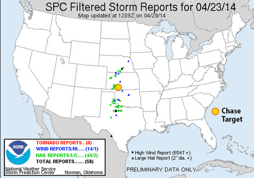
By morning, HRRR and RAP forecast reflectivity, CAPE, low-level SRH had all pointed further south than my target area: mainly along the Texas Panhandle/Oklahoma border. Typical of my evening-before-skills: I would have left myself with a 100-150 mile drive the next morning. Anyway, there was still hope for more limited convection up in my standstill target area, but it was a lot less promising. Storms ended up firing as expected along the dryline after 21Z but the greatest activity was just as suggested by HRRR. A few small storms finally did gain some momentum further north, with my target area tucked in the cirrusy realms between. By some miracle, a couple 1.5-inch hail reports came in within 50 miles, so I picked up a consolation prize for that. Storms further south looked a lot better, and reports of rotating wall clouds did come in. However, supercells that formed were apparently high-based, and those that drifted into Oklahoma did not stay isolated, forming unproductive clusters insttead. As of 03Z, no tornadoes had been reported.
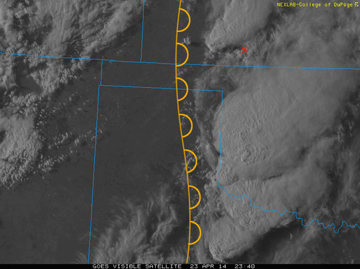
My target area between convective clusters.
