Chase Target: Marlow, Oklahoma
This is the first of several severe weather days that have had storm chasers on pins & needles for the past week. As the first day has drawn closer, the setup has looked less and less ideal, with the best upper level dynamics arriving later and later. I'm on overload from too many things to wrap up tonight, so this will be pretty basic:
Trying to find the best compromise between available instability, breakable cap that will permit surface based storms and some hope of seeing higher bulk shear from the lagging trough. NAM and GFS are forecasting precipitation after dark in central or southwest Oklahoma where CAPE is forecast around 3000 j/kg and maintaining 2000+ j/kg after sunset with 65 degree dewpoints per NAM and GFS. RAP laughs heartily at this however and wants to mix it out and you are lucky to get upper fifties. If NAM and GFS hold a little of their own, the Southwest/West-Central Oklahoma area corresponds to a Lid Strength Index below 1 for hopefully surface based storms. If that takes place, forecast 0-1 km SRH could rise from 100 to 200 m^2/s^2 with nice open clockwise hodographs.
Results:
Nearest Tornado Report: None
Nearest Severe Report: 112 Miles West (1.25 Inch Hail)
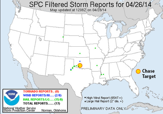
Bah. What a sad setup. Moisture definitely tanked, mixed out, and got strongly capped. What did manage to form was mainly centered in Texas right at the SW corner of Oklahoma, but got choked off before it could get any further east.
[Edit:] A couple more hail reports came in around 10Z that morning, one of which was 24 miles from my target area. Reports from 0530-1200Z don't get tallied at the Storm Chase Game site, theorizing that people should be getting sleep from Midnight through 7 AM I imagine :)
