Chase Target: Malvern, Arkansas
A surface low over the Kansas/Nebraska border drapes a dryline across eastern Kansas/Oklahoma/Texas. A broad zone of 3000+j/kg CAPE in E TX grows thinner by 00Z, but broad 2000-2500 j/kg reaches into the southwest half of Arkansas and throughout Louisiana. A negatively tilted upper level trough sweeps 65 kt flow over the dryline and warm sector during the course of the afternoon and evening leading to 60kt of deep layer shear. Large areas of 100-250 m^2s^2 SHR broadening east of the dryline as the afternoon progresses into evening particularly centered over the majority of Arkansas. NAM forecast convection kicks off by 18Z and effects the SW half of Arkansas through afternoon and evening with LCLs down to 250-500 meters and impressive hodographs. I'm positioning at Malvern for best reach at forecast convection within these parameters.
One big challenge I see is the cap opening up really early—before 18Z—with Lid Strength Index below 1 and into negatives over much of Arkansas. Early convection could sap boundary layer moisture, but models still forecast large areas of 65-70 degree dewpoints and 2000+ j/kg CAPE into the evening. I would not chase this area or setup in actuality—terrible chase terrain. Although storms should not be traveling too fast.
Results
Nearest Tornado Report: 41 Miles Northeast
Nearest Severe Report: 31 Miles Southeast (Wind: Downed Trees)
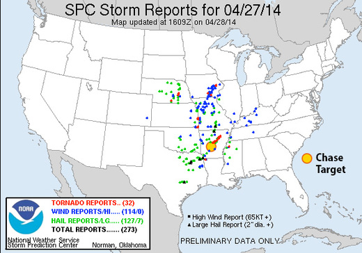
This setup led to a terrible situation in Arkansas. As of 04Z, the only tornado reports in Arkansas have come from a long track supercell that hit numerous residential areas, and caused enormous damage in the towns of Mayflower and Vilonia resulting in at least 10 deaths. I was watching this storm on Radar Scope earlier in the day when it first formed, got a severe warning, then developed a low level couplet. I had to log off before it received a tornado warning. If I were, by some bizarre reality, actually chasing in the jungle today, I probably would have made an attempt to pace this storm along the northwest side of Little Rock—not that I would have found a clear view through hills and trees in any case. Not a good place to be with storms like this. My thoughts and sympathies go out to all affected by this storm.
