Chase Target: Paulding, Mississippi
Upper level low over easter Iowa with 70-80 kts of flow over Louisiana/Mississippi/Alabama. Surface low is stacked right under its upper level partner. A cold front wraps through western Kentucky/Tennessee, northwest Mississippi and northern Louisiana at 18Z and pushing slowly southeastward during the afternoon. Upper 60 to 70 degree dew points are in place early with surface winds veered more strongly the further north you go approaching the front. CAPE values over the southeastern two-thirds of Mississippi, boot of Louisiana, and west-central Alabama start off over 3000 j/kg at 18Z and get eaten away by convection as the day goes on. Bulk shear over this strong instability is over 60 knots early on but relinquishes its hold over most of southern Alabama by late afternoon. 0-1km SRH is in the 150 m^2/s^2 over the southern third and a central pocket of Mississippi and floats ahead of developing convection. EHI is pegged over 3 in those central and southern pockets of Mississippi at 18Z when convection is heating up. Convective models show an early start to storms with supercells forming by midday in Mississippi and moving into Alabama during the afternoon. This is still early, messy convection and difficult to untangle options.
[Edit/Update 2230Z:] An ongoing MCS from yesterday's storms on the gulf coast has not given up all day. Outflow and massive anvil cirrus has kept the southern two-thirds of Alabama and southeastern quadrant of Mississippi from heating up and reaching forecast instability. Storms have been trying to get going ahead of the cold front across Mississippi—much later than anticipated—but struggling much of the past couple hours. One storm about 70 miles southeast of my target area has picked up a tornado warning and is moving roughly eastward. It's pretty strung out, the velocity couplets look anemic to my eye, and it's not moving into better instability. So hard to say if it will last long.
Results:
Nearest Tornado Report: 632 Miles East-northeast ...ehhh, probably ridiculous I'm tallying that...
Nearest Severe Report: 64 Miles West-southwest [1 Inch Hail]
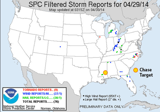
It's amazing how soundly the non-stop MCS on the gulf coast turned the severe risk around for the region. Reminds me of May 11, 2011, when I woke up from the roach motel in Pratt, Kansas, on theoretically the strongest setup of the trip, to find an unexpected MCS and inbound anvils from Texas completely erasing the storm environment. It sure is a lot better to tank a forecast from home than 800 miles out! (The tornado-warned cell that was approaching Paulding did drop some meager hail with a couple reports 64+ miles out.) It's a great relief all around that communities in the south got a reprieve from the last couple days of ruthless weather.
