Chase Target: Davidson, Oklahoma
Looking at the southern portion of this setup: it features a fairly neutral-tilt trough over western US with 50-60kt 500 Mb speed max edging eastward over the Panhandles/western Oklahoma/northwest Texas/southwest Kansas. The 18Z NAM forecasts 40-50kt bulk shear over northwest texas to northwest Oklahoma by 00Z and increasing thereafter. The 18Z GFS spreads that out more, but pushes it further northwest. An elongated surface trough is forecast to tighten up from northeast Colorado to eastern Nebraska with a dryline retreating westward during the afternoon/evening and ending up at 00Z from western Iowa through central Kansas, southwest Oklahoma and south from there into Texas with mid 60 dewpoints in place. CAPE values range from 2000 (GFS) to 3000 (NAM) j/kg east of the dryline by mid-late afternoon. By 00Z, GFS breaks out convection north of the Red River while NAM plants south of the Red River. Both models/areas feature widening hodographs toward and after sunset. NAM features EHI building from 1.0-3.0 around and south of Vernon Texas from 00Z-03Z with 0-1km SRH approaching 300 m2/s2 by 03Z. LCLs start to drop toward 1,000 meters from 00Z-03Z as well.
[Update 1515Z:] Latest NAM, HRRR and RAP reflectivity forecasts are showing some differences in where convection will initiate and strengthen. 06Z and 12Z NAM fires things up right over my target area. RAP and 12Z HRRR however are lighting up further east at mid afternoon with HRRR firing a weaker second round over my target area a couple hours later. It seems like HRRR is anticipating the dryline sitting further east around 21Z when convection initiates, and then the dryline starts retreating right after that. I'm interested to see if SPC nudges the risk area eastward or not. The difference is about 50 miles, so if I were there, I'd be pleased to just sit in my current location, watch the dryline mark itself out, and then adjust if needed as cumulus gets more agitated.
Results
Nearest Tornado Report: 30 Miles Southeast
Nearest Severe Report: 18 Miles East-northeast [1.5 Inch Hail]
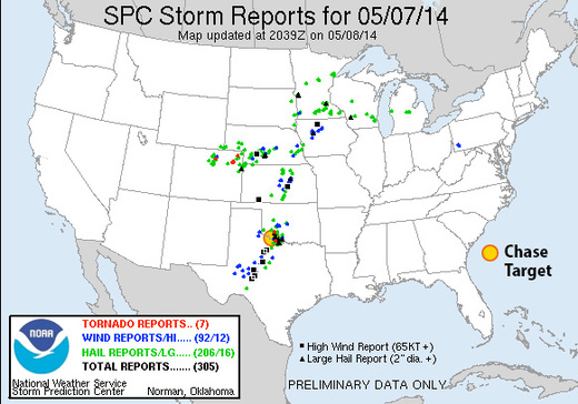
Storms that fired near southwest Oklahoma did fairly well toward 00Z with a tornado-warned cell crossing the Red River near my target area. Apparently there was a spotter report of a tornado near Burkburnett, but I haven't seen it posted to SPC storm reports as of 0500Z.
[Update May 8, 2014:] SPC is still updating storm reports, and have now plotted two new tornado reports: 30 miles southeast of my target, near Burkburnett, and 40 miles north-northeast, in the Wichita Mountain Wildlife Refuge.
